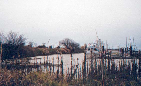
Scotch Pond
 Photograph taken by:Denise Cook
Photograph taken on:Saturday, November 24, 2001
General Information
Type of Resource: Landscape
Common Name:
Address: Garry Point Park
Neighbourhood (Planning Area Name): Steveston
Construction Date: Scott-Cdn Cannery 1899; Scotch Pond c.early 1950's
Current Owner: Municipal Government
Designated: Yes
Statement of Significance
Description of Site
Scotch Pond consists of a pond, originally a slough, dredged in the early 1950s and connected by a channel to the Strait of Georgia. Along with the pond are the remains of wooden boardwalk pilings which run directly along the south edge of the pond and were constructed in 1899 as part of the Scottish Canadian Cannery operation. The Pond is located on Garry Point Park in the tidal flats of Sturgeon Bank, on a line that is a western extension of Chatham Street.
Statement of Values
Scotch Pond’s heritage values include its historical associations, first with the use of the original slough at Garry Point as the location of a year round Musqueam Indian settlement until the late 1890’s, with the Scottish Canadian Cannery built by Malcolm and Windsor in 1899, with the Atagi Boatworks located at the head of the slough and operated until Japanese internment during World War II, and finally with the dredging operation undertaken in the 1950’s by the Canadian Fishing Company.
Scotch Pond has value as an early and rare example of an industrial development and small community built away from the shoreline within an area of tidal flats, constructed entirely on wooden pilings, its only connection to the land a narrow wooden boardwalk.
Character Defining Elements
Key elements that define the heritage character of the site include:
· The wooden pilings along the south edge of the pond which are the remains of the original connecting boardwalk from the Scottish Canadian Cannery to Steveston
· The Scotch Pond as it exists today, including a small rectangular wooden building and wooden boat docks, which are used by the fishing industry through the Scotch Pond Heritage Co-operative
· The natural landscape of the Sturgeon Banks tidal flats as a context for this heritage feature
History
The land in the vicinity of Scotch Pond has a long and interesting history. Garry Point was the location of a year round Musqueam Indian settlement, which increased in population during the eulachon and sturgeon migrations, the salmon season and berry gathering seasons. At the head of the slough, now Scotch Pond, the Musqueam maintained a burial ground. The Musqueam occupied this village until the late 1890’s .
The Scottish-Canadian Cannery was built by Malcolm and Windsor in 1899, and was acquired by United Canneries of BC in that same year. As the Scottish-Canadian Salmon Packing Company it first operated in 1901, packing 48,433 cases of salmon. In 1915, a Mr. Graham purchased a half interest in the company and leased the lot, which he tried to sell in 1919 and again in 1923. The land was finally leased to the Canadian Fishing Company in 1925 who used the facility as a fishing station.
The cannery was located on a slough in the tidal flats off Garry Point. The complex consisted of the cannery and associated outbuildings, decking and net racks, workers’ housing, and a boardwalk that commenced on the dyke at the west end of Chatham Street. All of the structures were built on pilings. The slough itself was known as a ‘pond’ because it provided safe wet moorage for fishing boats associated with the cannery. Historical photographs of the area at high tide make the cannery look as though it is floating at sea, attached to land by a thin boardwalk. The Atagi Boatworks was located at the head of the slough. Beginning operation in 1905, it was acquired by Mike David Boatworks in the 1940’s following internment of the Atagi family, then by a Mr. Takugaki, around 1949. The remains of the boatworks were removed from the site sometime in the mid-1970’s.
The Canadian Fishing Company dredged the slough in the early 1950’s to provide additional safe wet moorage and net mending and storage space, mainly for gillnetters. Local fishermen co-operated to create one of the longest continuous net floats on the coast, with associated net sheds and wharf. Scotch Pond was also used as a swimming hole.
Scotch Pond was purchased by the City of Richmond in 1989. A group of fishermen formed the ‘Scotch Pond Heritage Co-operative’ and now operate and manage a net float, net racks and net storage facility.
Architectural Significance
No information available.
Landscape Significance
Landscape Element
Scotch Pond, tidal flats, surrounding landscape
Design Attributes
Historical photographs show the evolution of the landscape in the area of Scotch Pond as it has been shaped to serve the needs of the fishing and canning industries. The boardwalk to the Scottish Canadian Cannery was constructed across the tidal flats off the west side of Lulu Island along the approximate line of a slough channel. The cannery itself was constructed on an angle to take advantage of another slough channel which provided river access and moorage for fishing boats. When Scotch Pond was created, it followed these original natural and built patterns, using the original Scottish Canadian ‘pond’ as access into the larger, dredged ‘Scotch Pond’. Today these features are evidence of the interaction of people with the land for a purpose, and visually represent two layers: the subtle layer of the original pilings of the boardwalk, and the subsequent construction and use of Scotch Pond.
Landscape Construction Method
The boardwalk was constructed of wooden piles. The pond was created by dredging operations.
Integrity
Alterations:Except for the boardwalk remnants, the Scottish Canadian Cannery has disappeared. The boardwalk pilings have been almost completely demolished, and exist merely as clues in the landscape. Scotch Pond as constructed in the 1950’s is still an important part of the landscape today, but the original slough that was the ‘pond’ for the cannery is no longer visible.
Original Location: Yes
Lost: No
Condition
The pilings and boardwalk remnants are in poor condition compared to the original. They are not obvious, yet when noticed they still manage to convey a sense of what existed there in the past.
Documentation
Evaluated By: Denise Cook, BLA, PBD (Public History)
Evaluation Date: Tuesday, January 15, 2002
Documents
Bauer, Joe. ‘Scotch Pond’ in Steveston Historical Guide, 1992.
Bob Ransford, Heritage Advisory Commission. ‘Scottish Canadian Cannery Boardwalk Remnants and Pilings’, heritage information form, 1998.
Bodnar, Diana. Report on Garry Point, Richmond, Department of the Provincial Secretary, Government of British Columbia, 1975. Location #6159, Richmond Archives.
Clayton, Marilyn. Personal communication.
Haig-Brown, Alan. ‘Scotch Pond Then and Now’, in The West Coast Fisherman, vol. 4, No. 1, July 1989, p.45.
Ham, Leonard. Archaeological Heritage Resource Overview of Richmond, 1987. Heritage Advisory Commission sous-fonds, 1-3-13, Richmond Archives.
Ralston, Keith H. BC Salmon Canneries, Provincial Archives, 1965, UBC Special Collections.
Richmond Museum. “Garry Point Park Historical Walking Tour”, nd.
Scotch Pond: A Proposal. Scotch Pond Steering Committee, 1900-1991.
Stacey, Duncan. Steveston’s Cannery Channel: A Social History of the Fishing Community, prepared for the Township of Richmond, 1986, Richmond Public Library.
Historical Photographs
Photograph No. 2151 dated 1908, Vancouver Public Library.
Photograph No. G-3492 dated 1927, BCARS.
Scotch Pond 1949, Joe Bauer Collection/Richmond Museum.
Scotch Pond 1952, Joe Bauer Collection/Richmond Museum.
Scotch Pond 1954-55, Joe Bauer Collection/Richmond Museum.
Location and Type of Plans Found
Geological Survey of Canada, 1921. UBC Special Collections.
Steveston BC. c.1895-1911. Richmond Archives Map Collection, Item #1985 132 12 and 13.
Waterworks Atlas Map of Garry Point and western part of Steveston Townsite, 1936. Item #1991 40 21, Richmond Archives.
 Translate