Cannery Row Heritage Area
 Photograph taken by:Denise Cook BLA, PBD (Public History)
Photograph taken on:Friday, August 10, 2001
General Information
Type of Resource: Heritage Area
Common Name:
Address:
Neighbourhood (Planning Area Name): Steveston
Construction Date: 1880-1920
Designated: No
Statement of Significance
Description of Site
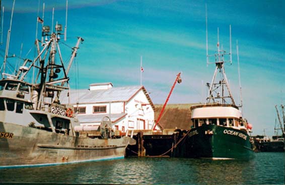
Richmond’s Cannery Row is a linear stretch of the South Arm riverfront between the mainland at Steveston and Steveston Island. So-called because of the plethora of canneries that were located here during the height of the fishery in the 1920’s, Cannery Row runs from Garry Point in the west to the foot of No. 2 Road in the east, and encompasses both the river channel and a portion of the mainland. Along its length are a number of industrial and utilitarian built resources related to the fishing and canning industries.
Statement of Values
The heritage value of the Cannery Row site is encompassed in its historical association to salmon canning and the fishing industry in Richmond late in the 19th and early in the 20th centuries. This area was shaped by these industries, which created large-scale structures along the riverfront, modified the landscape, and influenced Steveston’s development and social structure during this era..
The location of this heritage area is also significant. The concentration of canneries developed here because of proximity to the fishing grounds. The deep quiet water between Steveston Island and the mainland allowed fishing vessels access to unload the catch, and transport ships to load the canned salmon for its overseas voyage.
The linear form of development along the riverfront was shaped through the activity and occupancy of the fishing, canning and boatbuilding industries. The overall form of land acquisition and development in this area was solely dependent upon the needs of these enterprises. The direct relationship of the canneries, shipyards and associated structures to the river is a result of the need for riverfront access and is an important aspect of the development of this area and in the evolution of its historic character.
There are social and cultural values inherent in this area as well. The canneries influenced the development of Steveston by bringing in businesses, workers and money which enabled Steveston to evolve into a busy, bustling, successful riverfront community. The area still has the ability to demonstrate how the canneries operated and their relationship to the river.
Character Defining Elements
Key elements that define the heritage character of the site include:
· The rough industrial and utilitarian character of the working waterfront
· The presence of the three remaining cannery complexes which create focal points along the river channel: the Britannia Heritage Shipyard, the Paramount Cannery complex and the Gulf of Georgia Cannery
· The large scale and continuous linear massing of the built form along the riverfront, with continuity provided by the pilings, wharves, and other built elements
· The immediacy of the river, Steveston Island, and the presence of the fishing fleet and its equipment which speak to the historic function of the area
· The form and massing of the existing buildings along Cannery Row, which are generally of wood frame and heavy timber construction.
History
Historic time period:
The significant time period for Cannery Row begins with the construction of the first canneries, around 1880, and ends with the demise of the canning industry, about 1920.
Extant resources:
Major resources currently recorded on the heritage inventory include the Gulf of Georgia Cannery, the Paramount Cannery complex, and the Britannia Heritage Shipyard. As well, there are many small-scale elements remaining. Even with the diminishing of the built resource, there is a tremendously strong association to Richmond’s history that can be successfully interpreted on this site.
Distinction:
Cannery Row is visually distinguishable today by its linear pattern of continuous development along the riverfront. It has a working riverfront character, and a relationship to the river that is evident in its historic development as an area with an association to a single industry.
Boundaries:
The southern boundary of the Cannery Row heritage area is Steveston Island. The boundary then extends west to Garry Point because it was the site of the Garry Point and Scottish Canadian canneries. The eastern boundary of the site is No. 2 Road, which ended the cannery construction and roughly coincides with the eastern end of Steveston Island. The northern boundary is more difficult to define. It follows Moncton Street east to Dunford Street, then Westwater Drive to Trites Road, then Dyke Road terminating at No. 2 Road. This boundary definition currently encompasses the B.C. Packer’s site; as this development progresses, the boundary will certainly be moved closer to the river to exclude development that has lost integrity due to new construction.
Overall sense of place and historic character:
Cannery Row still maintains a unique sense of place because of the remaining evidence of its history, and the large scale and continuous massing of its built form. The immediacy of the river and Steveston Island, as well as the presence of the fishing fleet and its equipment contribute to the historic character of this area.
Historic Criteria:
Area History:
In 1882, the Township of Richmond issued its first two trade licences to the Richmond and Phoenix canneries. During the 1890’s, the Fraser River canning industry began to boom. Between 1890 and 1900, more than 20 canneries were built in Richmond, 14 of them operating in the vicinity of Steveston. The concentration of canneries developed here because of proximity to the fishing grounds, and the deep quiet water between Steveston Island and the mainland, which allowed both fishing vessels to dock to unload the catch, and subsequently, transport ships to load the canned salmon for its overseas voyage.
Until the late 1880’s, in character with other commercial development in this era, the salmon canning industry was characterized by small firms and local proprietorship, with manual operations based on a single canning line. The first direct shipment of salmon from the Britannia Cannery at Steveston that was not first exported to Victoria or San Francisco marked the beginning of the Fraser River and its industries as a major commercial centre.
During the period of intense expansion in the 1890’s, amalgamations of cannery operations began to be carried out in order to deal with fluctuations in fortunes caused by the size of the annual salmon run. Three large firms, the Anglo-British Columbia Packing Company, the Victoria Canning Company and Ewen and Company accumulated and controlled over 70% of the annual sockeye pack. Even more sweeping, in 1902, the British Columbia Packer’s Association absorbed 22 existing canneries. Large companies now dominated the industry, and the importance of local capital, and thus local control declined.
The cannery complexes were constructed on the river side of the dyke. Adjacent to the canneries were residences for the workers and fishermen, who were mainly Japanese, Chinese and First Nations people. Each group lived in separate functional dwellings. Work in the canneries and on the fishing boats was seasonal, and the labour force was migratory, arriving from cities and native villages. After the work day or during the weekly fishing closure, there was a social aspect to the canneries, as workers gambled, played music or planted gardens, with children running everywhere, creating a lively mix of cultures.
The invention and adoption of the butchering machine around 1905 altered the industry’s labour history by eliminating the most skilled and highly paid cannery workers. Although cannery operations had a degree of mechanisation in 1900, butchering did not, a task that was carried out mainly by Chinese workers. This technology also changed the layout of the cannery buildings, eliminating the wing used for butchering. Other technological changes between 1903 and 1913 included the introduction of the sanitary solderless can in the canneries, and gasoline powered engines and nets in the fishing fleet.
In 1913, a landslide at Hell’s gate on the Fraser River blocked the passage of salmon upstream and marked the beginning of the end of the intense and lucrative salmon canning industry. Many of the canneries were adapted as shipyards or canning and reduction plants for non-salmon fishery products such as canned herring and fish oil and meal.
Although Cannery Row is still one of the major fishing harbours on the west coast, most of the canneries acquired by B.C. Packers in 1903, and others in Cannery Row and elsewhere, have been shut down and either sold or are used as storage and net sheds for the fishing industry. Most of the modern fishing fleet are privately owned by owner-operator fishermen. This fishing legacy is a reminder of the major role played by the fishery and fish canning industries in the history of Richmond.
Sites:
There is the possibility that Coast Salish settlements once existed in the Steveston area, with one recorded site in the vicinity of Garry Point.
Development pattern:
Cannery Row has evolved out of the Fraser River marsh estuary, and has gone through extensive cultural modifications over time. The site is an example of an evolved cultural landscape shaped through use by activity or occupancy, in this case, the fishing, canning and boatbuilding industries. The overall form of land acquisition and development in this area was solely dependent upon the needs of these industries.
Cannery complexes were built on the river side of the dyke and consisted of clusters of buildings which were either involved in the processing of fish, such as the cannery and ice house, and support structures, which included worker’s and managers’ housing, boatyards, net lofts and wharves. A wooden boardwalk system constructed on piles above the foreshore marshes created a ‘main street’ for Cannery Row, running along its entire length, with connections from the worker’s housing to the cannery complexes. The direct relationship of the canneries, shipyards and associated structures to the river row is a very important aspect in the development of this area and in the evolution of the historic character. Historically, the Row waterfront was a hodge-podge of closely packed buildings with residences and workplaces mixed together. With the demolishing of most of these original vernacular structures along the row, this pattern of building has mostly been lost, but can be seen in early plans of the area and in the Murakami boatworks and residence on the Britannia site.
Since the 1984 heritage inventory, many of the remaining cannery buildings no longer exist. Fortunately, the lives of some of the early cannery structures, notably the Gulf of Georgia and Britannia canneries, were prolonged due to conversion to shipyards and reduction plants early in the century. The Paramount Cannery buildings were reconfigured in 1956-57 to become the major plant for the Nelson Brothers Fisheries. Much of the eastern portion of Cannery Row is owned by the Small Craft Harbours Branch of the Federal Government for the fishing fleet, and in 1989 the Steveston Harbour Authority took over the management of most of the fishing vessel facilities.
Since the 1980’s many development proposals have been brought forward for the waterfront around Steveston and along Cannery Row, some posing a serious threat to the historic character of the area. In 1988, Steveston Landing was developed at the foot of Fourth Avenue, and much of the BC Packers site has recently been demolished. However, due in part to a nearby residential development, the Britannia Shipyard now functions as an historic site and interpretive facility and the Gulf of Georgia Cannery is an important federally operated museum and interpretive site. As well, accessible portions of Cannery Row have been connected as part of the City’s open space and trail system.
Architectural Significance
Design Features
Significant buildings:
Established in 1890, the Britannia shipyard and cannery is the oldest surviving structure on the Steveston waterfront, and possibly the oldest cannery building in the province. Included in the complex are cannery worker’s housing, boatworks, office, winch shed, and a seine loft that was part of the Phoenix cannery complex. The Gulf of Georgia Cannery is the most westerly surviving fish canning and processing plant in the Cannery Row. Both of these buildings have retained their L-shaped form. The Paramount Cannery complex consists of a cannery building and reduction plant, currently used for gear storage and as a net loft.
Overall built form:
The three remaining cannery complexes create focal points along the river channel. Connecting them is a dense pattern of large and small buildings, most associated in some way with the fishing industry, others representing new development. The Cannery Row still retains something of its original character, particularly in the eastern section.
The area still manages to convey a sense of the sheer size development at the height of the canning industry, and the massive undertaking it must have been to construct all of the canneries, workers housing, net lofts, and other structures associated with fishing and canning.
Portions of the original wooden bulkhead still exist at the Britannia site, while other areas of the foreshore are supported by riprap and concrete retaining walls. There is a continuous upland area created between the constructed bulkheads and Dyke Road which creates a reclaimed area of land. As well, continuity is provided by the pilings and wharves which dominate the waterfront.
Aesthetic qualities:
Most of the existing buildings along Cannery Row are of wood frame and heavy timber construction. The roughness of a working waterfront, and the large-scale massing of many of the buildings with their wooden piling supports and associated wharves and docks still conveys a sense of cohesiveness.
Landscape Significance
Design Attributes
Natural features:
Natural landscape components include marshes and fish habitat areas. Because the area is so built up, there is little sense of natural ‘river bank’ anywhere along the Cannery Row.
Cultural traditions:
Many of the structures built to house workers in the canneries may have been based on cultural practices. As an example, the First People’s House in the Britannia complex is thought to have been constructed to resemble a traditional longhouse. Other than this, the multi-ethnic nature of the Row in its heyday is no longer seen in the existing landscape.
Circulation and open space:
Circulation in and around the Cannery Row consists of the river, the developed roadways and a trail system. Historically, circulation related to Row activities would probably have centred on the boardwalk main street and the river system. Within the row area itself there is little open space as such, except for the public space maintained at the Gulf of Georgia and Britannia sites. However, the open space of the river creates an impressive panorama for this area.
Vegetation:
Visually, vegetation is not a major component of the Cannery Row landscape. On the mainland side, the vegetation along the Row consists of pockets of mixed, disturbed vegetation, grasses, with an occasional cluster of trees. Most of the historic vegetation has been altered due to dyking, drainage and fill, although Steveston Island appears to represent a more natural ecosystem. Historically, many of the worker’s homes associated with the canneries would have had cultivated gardens and orchard trees nearby for food production.
Views, vistas, perceptual qualities:
Views from the river into the heritage area are truncated due to the dense development along the river edge, with the exception of Garry Point from which there are views to the mountains in the north. From the bank, there are significant views up and down the river, and south to Steveston Island and beyond.
Water bodies or features:
Cannery Row itself, formed by Steveston Island in the South Arm is the significant water body associated with this site. Cannery Row developed because of the existence of this water feature.
Small-scale elements:
Most of the small-scale elements that still exist along the row consist of pilings and wharves. The original wooden bulkhead is still in place only at the Britannia site.
Integrity
Alterations:Overall, Cannery Row does not display a high degree of integrity.
Location:
Cannery Row maintains integrity of location. Most of the fishing and canning activities that have shaped this area took place in the river channel or on adjacent land due to the proximity of fish and deep water for ships. Although land uses have changed, the remaining elements, and new ones, maintain the same relationship to the river.
Design:
Integrity of design along Cannery Row has been compromised. Significant change in land use, the removal of many extant features and the infill of new development has greatly affected the original design elements of Cannery Row and its environment.
Setting:
The physical environment of the river and the land has not been altered significantly over time. The wharves, boats and equipment related to the fishing industry also help to maintain an integrity of setting.
Materials:
Integrity of materials used in the construction of Cannery Row is somewhat compromised. Although some traditional building materials are still evident on the site, changes to many of the buildings have required the use of different materials. On a larger scale, new residential and commercial developments are constructed of incompatible building and landscape materials.
Workmanship: Integrity of workmanship in the built environment has disappeared as the resources have disappeared. However, the active fishing industry in this area continues to retain some of the traditional practices and uses for the buildings and structures that remain.
Feeling:
The loss of much of the original built fabric lessens the continuity of Cannery Row as a linear area or feature, and therefore the feeling of the place. However, from the water side especially, the sense of place is still evident to some degree.
Association:
Association is the most vital remaining aspect of integrity. Cannery Row is part of Richmond’s soul, with its direct association to the fishing and canning industries, and the people whose lives were shaped and affected by them.
Lost: No
Documentation
Evaluated By: Denise Cook BLA, PBD (Public History)
Evaluation Date: Friday, August 10, 2001
Bodnar, Diana. Report on Garry Point, Richmond, Department of the Provincial Secretary, Government of British Columbia, 1975. Location #6159, Richmond Archives.
Christopher Phillips and Associates. Britannia Heritage Shipyard Park Concept Plan, 1993.
“Demolition frustrates Steves”, Richmond News, August 19, 2001.
Kidd, Thomas. History of Lulu Island and Occasional Poems, Wrigley Printing Company Ltd., 1927. University of British Columbia Special Collections.
Leaming, Ruth. “Salmon Canning – A Century of Progress”. Historical Vignettes of Richmond, Richmond Centennial Society, 1979.
Lyons, Cicely. Salmon, Our Heritage, B.C. Packers Ltd./Mitchell Press, Vancouver, 1969.
National Park Service. “Defining Boundaries for National Register Properties”, US Department of the Interior, 1999.
Norman Hotson Associates Ltd. Steveston Waterfront Conservation, 1985. Location #6159, Richmond Archives.
Reid, David J. The Development of the Fraser River Salmon Canning Industry, 1885 to 1913, Federal Department of the Environment, 1973. Location #6159, Richmond Archives.
Richmond Heritage Inventory Phase I, 1984.
Ross, Leslie J. Richmond, Child of the Fraser, Richmond Centennial Society, Richmond, B.C., 1979.
Stacey, Duncan. Steveston’s Cannery Channel: A Social History of the Fishing Community, Corporation of the Township of Richmond, 1986. Location #6159, Richmond Archives.
Steveston Area Plan: Heritage Studies of Steveston. Township of Richmond Planning Department, 1984.
Yesaki, Mitsuo. Steveston Cannery Row: An Illustrated History, Lulu Island Printing Ltd., Richmond B.C., 1998.
Historical Photographs:
Location and Type of Plans Found:
Fraser River Canneries, British Columbia. Chas. E. Goad, Civil Engineer, July 1897. UBC Special Collections.
Geological Survey of Canada. Fraser River Investigation: Topographical Maps 1923, UBC Special Collections.
Waterworks Atlas Map, 1936. Municipal Records, Item #1991 40 41, Location # Maps 20, Richmond Archives.
Municipality Sheets of Richmond 1925. Misc. Planning Department Maps, MR SE 520, Richmond Archives
 Translate