Terra Nova Heritage Area
 Photograph taken by:Denise Cook
Photograph taken on:Friday, August 10, 2001
General Information
Type of Resource: Heritage Area
Common Name:
Address:
Neighbourhood (Planning Area Name): Thompson
Construction Date: 1868-1930
Designated: No
Statement of Significance
Description of Site
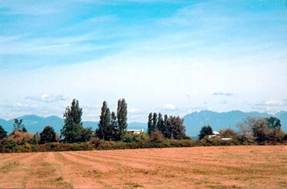
Settled in the late 1800s, Terra Nova is a section of land in the northwest corner of Lulu Island, its location surrounding it on two sides by water. This place offers the viewer vistas in almost all geographical directions and across a wide variety of landscapes in a rural area dominated by the river foreshore, the roadway and agricultural fields.
Statement of Values
The primary heritage value of Terra Nova lies in its historical association with the development of a very early settlement in Richmond. Used by the Musqueam, then claimed by migrants from the Maritimes, this rural landscape was among the earlier Crown Grant subdivisions, and has an agricultural and fishing history, both of which are reflected in its heritage features.
Terra Nova affords a rare opportunity to experience the landscape, buildings, and development patterns of an early Richmond settlement. The built structures include both settlers homes and cannery buildings in a pattern which recalls the early settlement along the dyke and foreshore. The natural environment, the cultivated landscapes around the homesteads, and the remnants of the cannery contribute to the unique sense of place of this heritage area.
Character Defining Elements
Key elements that define the heritage character of the site include:
· The rural landscape character, dense vegetation, the relationships of structures to the landscape, and Crown Grant boundaries dating from1890 that still define the area today
· Historic buildings which are residences of the original and early settlers in the area, several of which are good examples of architectural styles, and others associated with the Terra Nova and Alliance canneries, providing housing and supplies for its workers
· The linear cluster pattern formed by these buildings and which speaks to the earlier settlement pattern of homes along the dyke, facing the river, and the integration of the farming settlement with the cannery works
· The view from Terra Nova which is in almost all directions, and has foreground, middleground and background components
· Remnant and small-scale elements including fence lines, paving, individual fruit trees, narrow lanes, mailboxes, and other evidence of a rich and complex cultural landscape located primarily in areas around the homesteads
· Wharf pilings and physical indentations in the foreshore, evidence of the Terra Nova and Alliance canneries
· An historic slough indicated through traces of place species and groundwater.
History
Time period:
The significant time period for the Terra Nova heritage area begins with the arrival of the first settlers around 1868 to about 1930 when subdivision of the land appeared to cease.
Extant resources:
There are five major built resources in the Terra Nova area, and a number of heritage trees that are included on the City heritage inventory.
Other historic resources include the documented presence of First Nations peoples, the Terra Nova and Alliance cannery sites, and the pattern of agricultural fields and homesteads that represent human interaction with the land. Overall, there are strong associations to Richmond’s history that can be successfully interpreted based upon what still remains and the stories contained in sites that are no longer there.
Distinction:
The Terra Nova area can be distinguished visually by its rural character, the dense vegetation, the relationships of structures to the landscape, and by Crown Grant boundaries dating from 1890 that still define the area today. While the majority of the heritage resources are located in the western part of the site, the entire area from No. 1 Road westward was historically, and is currently, known as the Terra Nova area.
Boundaries:
The boundaries for Terra Nova begin with the original Crown grant of Lot 4 to Hugh Youdall in 1890, and Lot 3 which extends east to No. 1 Road. They include Westminster Highway to the south, the Fraser River to the north and west, No 1 Road in the east, which includes the Old Field conservation lands. Also included is the foreshore outside the dyke to the north and west for environmental and viewshed reasons, as well as incorporating the location of cannery operations in this area.
Overall sense of place and historic character:
This is a rural cultural landscape with an agricultural and industrial history, both of which are reflected in its heritage features. The built structures, the natural environment, the cultivated landscapes and historical associations contribute to the unique sense of place of this heritage area.
Historic Criteria:
Area History:
A Musqueam shellmidden at Terra Nova is the first evidence of human settlement in this area. The site was probably used during salmon and sturgeon runs, and for harvesting crabapples. The Terra Nova slough complex provided a means of transportation in this area, and it is speculated that First Nations people could canoe from Musqueam on the mainland, through the Sea Island sloughs, across the Middle Arm of the Fraser River to Terra Nova.
The first non-native settlement occurred at Terra Nova beginning in 1868. Ease of access by water and available farmland drew settlers to the northwest corner of Lulu Island. A Crown Grant for section 3 was acquired in 1868 by Royal Engineer William McColl, and for section 2 in 1879 by D.J. Robson & J.G. Smith, both signatories to the petition for incorporation. It is possible that the McColl grant later became the D.S. Milligan estate.
In 1886 a dispute arose over the Crown Grant for section 4 among four settlers including Hugh Youdall and D.S. Milligan. In 1890 the land was awarded to Hugh Youdall on the provision that he reimburse Milligan for improvements made to the property to date. Part of Youdall’s argument for acquisition of the section rested in the petition of five settlers and fishermen who had apparently been squatting on the property since 1886 and were anxious to secure title to their homes. The petition was signed by James Mellis, Joshua Parsons, Thomas William Horne, Robert Gordon and George Haugh who named their home Terra Nova, or New Land. It is not known which settler hailed from Newfoundland. Like most early settlers they dyked and ditched their holdings to create viable farm land until the Lulu Island West Dyking District was activated in 1905. It is possible that some of these local farmers participated in the fishery as well.
James Thompson was a farm hand, then manager, of the Milligan farm until 1896 when he purchased his own land in Terra Nova. Thompson was a prominent resident of Lulu Island, and serving on the school board and becoming and active member of the Methodist church.
The Terra Nova Cannery was constructed on the Middle Arm by Duncan and John Rowan in 1890-1891, and, immediately upstream, the Alliance Cannery was built in 1895. The Terra Nova Canning Co. ceased operation in 1898, while the Alliance changed hands and continued production in the same location until both were purchased by B.C. Packers Association in 1902. They began operating as a unit under the name ‘Terra Nova’ until the Imperial plant was demolished in 1903. The original Terra Nova cannery continued until 1928, after which it was used for net storage and as a fish station until the 1970’s when the buildings were removed.
With the canneries came workers, and the construction of housing, net sheds and wharves. Together with the local farming families, the employees at the canneries and the fishermen created a need for services. The small community of Terra Nova eventually included stores, churches and a school, plus a mail stage/passenger/freight service operated by James Mellis and later, his son William. Written documents indicate that a brickworks was located in the vicinity of Westminster Highway and the dyke, but primary sources to show this have not yet been located.
Following World War II, a portion of the area was purchased for veteran’s housing which was not constructed. The most recent agricultural activity in the area was a market garden and retail outlet which operated until the early 1980’s.
Although the earliest reference to Terra Nova originated with the five settlers of section 4, the name referred to sections 2 and 3 as well. In recent years, the area has become the topic of intense debate regarding its rezoning to allow residential development, and thus the future of its historic and natural character. The creation of a park in this area may serve to protect, enhance and interpret the historic character.
Sites:
In addition to the dwellings, significant historic sites near and associated with the Terra Nova Heritage Area include an archaeological site, a shellmidden, found on the Terra Nova slough at the Tait farm near the intersection of No. 2 Road and River Road.
Development Patterns:
Early historic development patterns begin with the five squatters living in Terra Nova prior to 1886, and the Crown Grants that followed.
The few documents that are available indicate that most subdivision in the area occurred approximately over the period from 1890 to 1925. In 1909, the initial subdivision of 8 lots was complete. Access was provided by a road which ran along the top of the dyke. In 1912 the Vancouver Harbour and Dock Extension Company was acquiring foreshore land that included the dyke and bits of the settler’s properties. This also appears to be the time during which narrow laneways were being acquired to access the lots in the south part of section 4, as No. 19 Road from No. 3 Road to the Gulf of Georgia, although gazetted in 1917, was not established until 194-. When completed, No. 19 Road was 33 feet wide and straddled the section line along which Westminster Highway runs today. Section 3 was subdivided in 1925.
While most of the cannery related buildings were located outside the dyke, plans from 1936 show smaller parcels of land subdivided from the original 8 lots and containing clusters of small buildings labelled ‘houses’, inferring that the cannery operations had acquired land south of the dyke to house its management or workers. The Cannery House and Store has been documented as a former floating scowhouse of the type associated with the Fraser River canneries, but with its barge sides removed and having been relocated onto land inside the dyke.
Lots along No. 19 Road (Westminster Highway) were created later, when access was provided from Westminster Highway. After the initial subdivisions there appears to be little activity and the historic pattern of land division and use is the same as that on current municipal plans. The new development to the east creates an abrupt division between two very different character areas, and impacts the views from the interior of the site.
It is significant that these early development patterns are present on current City maps, indicating that the process of settlers moving onto the land and dividing it up through various transactions is still evident on the ground.
Built Form and Structures:
Significant buildings:
Significant buildings in Terra Nova include: Cold Comfort Farm (2840 River Road, ), the Cannery House (2740 River Road), the Cannery House and Store (2760 River Road), Parsons House (2640 River Road), the Edwardian Cottage (2680 River Road), and the Thompson House (4860 River Road).
These buildings are residences which have direct association to the early settlement of the area, and the Terra Nova and Alliance canneries which provided housing and supplies for its workers. Several of them are good examples of architectural style, including the Queen Anne style Parson’s house, and the blend of vernacular Maritime styles as seen in the Cold Comfort farmhouse.
Architectural Significance
Design Features
Most of the extant structures are of wood frame construction, and most are oriented to Dyke Road and the river, fronted by a drainage ditch and the dyke. The Cannery House, Store and Edwardian Cottage interrupt this pattern, creating an interesting grouping that represents the remains of a larger cluster of small structures opposite the cannery operations. Infill buildings near these extant resources have disturbed the integrity of the early built form and the relationship of the buildings to other features such as the roadway, fence lines, and each other.
Aesthetic qualities:
The original homestead structures exhibit a cohesiveness in their siting on the individual lots as they are set back slightly on the property and are oriented toward the river, with agricultural fields stretching out behind. The massing and scale of the original buildings is consistent, and they have a good fit within their individual landscapes and the area as a whole.
Landscape Significance
Design Attributes
Natural systems and features:
Like most of Richmond, Terra Nova has a flat topography and few prominent natural features. The need to drain the flat land influenced the location of the dyke and thus the early roadway. The land generally slopes down to the river edge, but this natural relationship has been changed with the construction of the dyke. The soils here were noted as being rich and suitable for farming.
Cultural traditions: None noted.
Circulation and open space:
When the dyke was constructed at Terra Nova, it changed the shape of the land creating a promontory at the northwest corner. Originally, the dyke was to have followed the western edge along the section lines to Steveston, but deep sloughs forced the alignment eastward to the top of Crabapple Ridge. The access road to lots 7 and 8 at the rear of the section was originally located on top of the dyke. Currently, there is no road access after the dyke turns southward, and the rear lots are accessed via Westminster Highway.
Most of the open space in this area is composed of the foreshore, the roadway and the interior agricultural fields. The internal open space is generally only glimpsed from the roadway through dense vegetation. Smaller open spaces are created by the yards and gardens associated with the homesteads.
Vegetation:
There are significant vegetation patterns in Terra Nova, including several important trees which appear on the heritage inventory. Most of these are associated with domestic gardens in the homestead sites and include holly, horsechestnut, oak, maple and yew. Other sites contain apple trees, remnants of early orchards. The Gordon property has one significant common pear tree, plus other pear trees planted by the wife of Robert Gordon. There are also agricultural fields with associated hedgerows and windbreaks, and tree-lined access drives, as well as the native vegetation associated with the foreshore, the ditches and the natural environment. Vegetation is a very important component of the heritage landscape, adding to its sense of time and place, although its growth over time has change the open quality of the site as seen in early photographs.
Views, vistas, perceptual qualities:
The view from Terra Nova is another of the major features of this area. The Terra Nova view has a particular association with this area as it could not occur anywhere else. With the flat topography of the delta this peninsula of land has a view in almost all directions, and has a foreground, middleground and background. The view is significant in the meaning that it has had for people over time. Internal views also present a layering of agricultural fields, fence lines, hedgerows and shelterbelt trees. Internal views are impacted by the development to the east.
Water bodies or features:
Terra Nova is the location of an historic slough, one of many which formed a complex of waterways on Lulu and Sea Islands. It consisted of at least two main channels, one draining into the Middle Arm and one across the tidal flats to Sturgeon Banks. As well, historically and currently, the area is oriented to the river which encompasses it on the northern and western sides.
Small-scale elements:
Remnant small-scale elements in Terra Nova are an important component of its sense of place. These include remnant and intact fence lines, paving, individual fruit trees, narrow lanes, mailboxes, pilings, and other evidence of a rich and complex cultural landscape. They are located primarily in and around the homestead landscapes.
Integrity
Lost: No
Condition
Overall, the Terra Nova heritage area has a high level of historic integrity.
Location:
This is the location where the original settlers subdivided and cultivated their land, and where the two canneries set up their operations, so the area maintains an integrity of location.
Design:
Integrity of design is somewhat compromised. The construction of large newer homes in the immediate vicinity of the heritage structures detracts from the scale, massing, structure and style of the area.
Setting:
With the exception of the filled sloughs, the original physical environment that characterized the development of this area is still present, although modified by human activity.
Materials:
Integrity of materials in this area has been compromised by unsympathetic development and construction of large homes.
Workmanship:
Because land uses have changed, the way in which people interact with the landscape has changed, from farming practices to the details in recent construction. Integrity of workmanship is somewhat compromised.
Feeling:
Terra Nova expresses both an aesthetic and historic sense of place.
Association:
There is a direct association in the patterns of land use and the historic buildings with the history and people of this area.
Documentation
Evaluated By: Denise Cook BLA PBD
Evaluation Date: Friday, August 10, 2001
Documents:
Ham, Leonard C. An Archaeological Heritage Resource Overview of Richmond B.C., 1987. GP 316, Government Publications, Richmond Archives.
Kendall, Victoria. Settlement Patterns in West Richmond, 1988, Richmond Archives.
Kidd, Thomas. History of Lulu Island and Occasional Poems, Wrigley Printing Company Ltd., 1927. University of British Columbia Special Collections.
Mellis family biography files, Richmond Archives.
National Park Service. “Defining Boundaries for National Register Properties”, US Department of the Interior, 1999.
Private papers of Mr. Don Gordon.
Reid, David J. The Development of the Fraser River Salmon Canning Industry, 1885 to 1913,
Federal Department of the Environment, 1973. Location #6159, Richmond Archives.
Richmond Heritage Inventory Phase I, 1984.
Ross, Leslie J. Richmond, Child of the Fraser, Richmond Centennial Society, Richmond, B.C., 1979.
Thompson Area reference files, 1-3-49, Richmond Archives.
Thompson family biography files, Richmond Archives.
Thompson family fonds, location #7121, Richmond Archives.
Historical Photographs:
Photograph No. 1978 3 22, dated 1898. Richmond Archives Collection, Richmond Archives.
Photograph No. 1985 4 840, dated 1962. B.C. Packers fonds, Richmond Archives.
Photograph No. 1977 15 33, dated 1975. Centennial Collection, Richmond Archives.
Photographs contained in the private papers of Mr. Don Gordon, various dates.
Location and Type of Plans Found:
Fraser River Canneries, British Columbia. Chas. E. Goad, Civil Engineer, July 1897. UBC Special Collections.
Geological Survey of Canada. Fraser River Investigation: Topographical Maps 1923, UBC Special Collections.
Map of the Municipality of Richmond, 1909. Misc. Planning Department Maps.
Municipality Sheets of Richmond 1925. Misc. Planning Department Maps, MR SE 520, Richmond Archives.
Trutch Survey, New Westminster District, sections 3 & 4, Block 4 N, Range 7 W, 1859. Item #1989 30 1, location #1242.
Waterworks Atlas Map, 1936. Municipal Records, Item #1991 40 10, Location # Maps 20, Richmond Archives.
 Translate